
Hochdorf topographic map
Interactive map
Click on the map to display elevation.
About this map
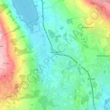
Name: Hochdorf topographic map, elevation, terrain.
Location: Hochdorf, Luzern, Schweiz (47.13551 8.26550 47.19430 8.31459)
Average elevation: 537 m
Minimum elevation: 460 m
Maximum elevation: 723 m
Die Höhenunterschiede innerhalb der Gemeinde sind gering. Der Baldeggersee liegt als tiefster Punkt der Gemeinde auf 464 m ü. M. Der höchste Punkt befindet sich auf einer kleinen Anhöhe östlich von Urswil auf 513 m ü. M.