Geolocate

Țintea topographic map

Click on the map to display elevation.

About this map

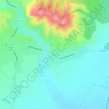
Name: Țintea topographic map, elevation, terrain.

Location: Țintea, Băicoi, Prahova, 105250, Romania (45.01236 25.88658 45.05236 25.92658)

Average elevation: 279 m

Minimum elevation: 238 m

Maximum elevation: 408 m

Gear up for your next adventure:

🧣Neck Gaiters - Versatile protection against wind and cold
🧥Softshell Jackets - Breathable jackets for active outdoor use
🧼Camping Hygiene Kits - Compact hygiene essentials for outdoor stays
🔦Head Torches - Hands-free lighting for hiking and camping
🧴Tick Removal Tools - Small, essential health tool for UK woodland and moorland

As an Amazon Associate, this site earns from qualifying purchases at no extra cost to you.