
Municipalité de Tsarévo topographic map
Interactive map
Click on the map to display elevation.
About this map
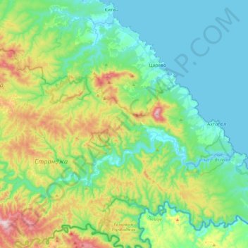
Name: Municipalité de Tsarévo topographic map, elevation, terrain.
Location: Municipalité de Tsarévo, Oblast de Bourgas, Bulgarie (41.97252 27.63731 42.22625 28.03575)
Average elevation: 129 m
Minimum elevation: -1 m
Maximum elevation: 517 m
Other topographic maps
Click on a map to view its topography, its elevation and its terrain.
Tsarévo
Bulgarie > Oblast de Bourgas > Tsarévo
Tsarévo, Municipalité de Tsarévo, Oblast de Bourgas, 8260, Bulgarie
Average elevation: 38 m
Sozopol
Bulgarie > Oblast de Bourgas > Sozopol
Sozopol, Municipalité de Sozopol, Oblast de Bourgas, 8130, Bulgarie
Average elevation: 11 m
Bourgas
Bulgarie > Oblast de Bourgas > Bourgas
Bourgas, Municipalité de Bourgas, Oblast de Bourgas, 8000, Bulgarie
Average elevation: 42 m