
Key River topographic map
Click on the map to display elevation.
About this map
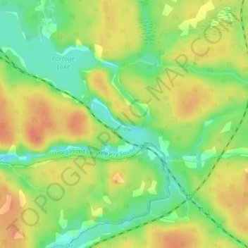
Name: Key River topographic map, elevation, terrain.
Average elevation: 193 m
Minimum elevation: 170 m
Maximum elevation: 212 m
Other topographic maps
Click on a map to view its topography, its elevation and its terrain.
Port Loring
Canada > Ontario > Parry Sound District > Unorganized Centre Parry Sound
Average elevation: 227 m
Harris Lake
Canada > Ontario > Parry Sound District > Unorganized Centre Parry Sound
Average elevation: 209 m
Dollars Lake
Canada > Ontario > Parry Sound District > Unorganized Centre Parry Sound
Average elevation: 215 m
Recollet Falls
Canada > Ontario > Parry Sound District > Unorganized Centre Parry Sound
Average elevation: 206 m
Memesagamesing Lake Dam
Canada > Ontario > Parry Sound District > Unorganized Centre Parry Sound
Average elevation: 227 m
Dokis Island
Canada > Ontario > Parry Sound District > Unorganized Centre Parry Sound
Average elevation: 196 m
Stormy Lake
Canada > Ontario > Parry Sound District > Unorganized Centre Parry Sound
Average elevation: 227 m
Arnstein
Canada > Ontario > Parry Sound District > Unorganized Centre Parry Sound
Average elevation: 233 m
Whistler Bay
Canada > Ontario > Parry Sound District > Unorganized Centre Parry Sound
Average elevation: 178 m
Key Harbour
Canada > Ontario > Parry Sound District > Unorganized Centre Parry Sound
Average elevation: 178 m
Clear Lake
Canada > Ontario > Parry Sound District > Unorganized Centre Parry Sound
Average elevation: 222 m
Grundy Lake Provincial Park
Canada > Ontario > Parry Sound District > Unorganized Centre Parry Sound
Average elevation: 197 m
Bosworth Island
Canada > Ontario > Parry Sound District > Unorganized Centre Parry Sound
Average elevation: 224 m
Restoule
Canada > Ontario > Parry Sound District > Unorganized Centre Parry Sound
Average elevation: 237 m
Dollars Lake
Canada > Ontario > Parry Sound District > Unorganized Centre Parry Sound
Average elevation: 215 m
Smith Bay
Canada > Ontario > Parry Sound District > Unorganized Centre Parry Sound
Average elevation: 217 m
Clear Lake
Canada > Ontario > Parry Sound District > Unorganized Centre Parry Sound
Average elevation: 236 m
Spring Lake
Canada > Ontario > Parry Sound District > Unorganized Centre Parry Sound
Average elevation: 317 m
Jack's Ridge
Canada > Ontario > Parry Sound District > Unorganized Centre Parry Sound
Average elevation: 254 m
Restoule Lake
Canada > Ontario > Parry Sound District > Unorganized Centre Parry Sound
Average elevation: 245 m
Golden Valley
Canada > Ontario > Parry Sound District > Unorganized Centre Parry Sound
Average elevation: 243 m
Loring
Canada > Ontario > Parry Sound District > Unorganized Centre Parry Sound
Average elevation: 241 m
Jack's Ridge
Canada > Ontario > Parry Sound District > Unorganized Centre Parry Sound
Average elevation: 254 m
Magee Island
Canada > Ontario > Parry Sound District > Unorganized Centre Parry Sound
Average elevation: 196 m
Jack's Ridge
Canada > Ontario > Parry Sound District > Unorganized Centre Parry Sound
Average elevation: 254 m