Geolocate

Adams topographic map

Click on the map to display elevation.

About this map

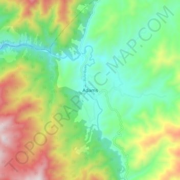
Name: Adams topographic map, elevation, terrain.

Location: Adams, Ilocos Norte, Ilocos Region, 2922, Philippines (18.42131 120.86357 18.50131 120.94357)

Average elevation: 517 m

Minimum elevation: 153 m

Maximum elevation: 1,185 m

Gear up for your next adventure:

📚UK Hiking Guidebooks - Detailed route descriptions for the Lake District, Peaks, and Highlands
🥾Women's Waterproof Hiking Boots - High-performance trekking boots designed for all-weather comfort
🧣Fleece Neck Warmers - Extra insulation for winter topographic surveys
👖Hiking Trousers - Durable trousers designed for rough terrain
Camping Shelters - Emergency and lightweight shelters for outdoor use

As an Amazon Associate, this site earns from qualifying purchases at no extra cost to you.