Geolocate

Labac topographic map

Click on the map to display elevation.

About this map

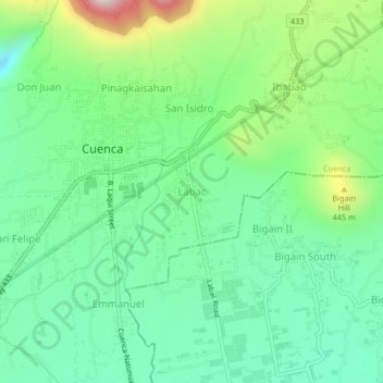
Name: Labac topographic map, elevation, terrain.

Location: Labac, Cuenca, Batangas, Calabarzon, 4222, Philippines (13.87622 121.03972 13.91622 121.07972)

Average elevation: 297 m

Minimum elevation: 124 m

Maximum elevation: 704 m

Other topographic maps

Click on a map to view its topography, its elevation and its terrain.

Bungahan

Philippines > Batangas > Cuenca

Average elevation: 222 m

Gear up for your next adventure:

🔥Reusable Hand Warmers - Maintain dexterity in your fingers for precise map handling
🛌Insulated Sleeping Mats - Crucial thermal protection when sleeping on cold, uneven ground
🥫Expedition Meals - Lightweight, high-calorie nutrition for long-distance hikers
🧊Personal Water Filters - Drink safely from mountain streams marked on your map
🌄Outdoor Binoculars - Compact binoculars for landscape observation

As an Amazon Associate, this site earns from qualifying purchases at no extra cost to you.