
Dunwoody topographic map
Interactive map
Click on the map to display elevation.
About this map
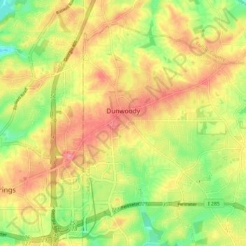
Name: Dunwoody topographic map, elevation, terrain.
Location: Dunwoody, DeKalb County, Georgia, United States (33.91500 -84.34793 33.97087 -84.26493)
Average elevation: 313 m
Minimum elevation: 254 m
Maximum elevation: 366 m
Other topographic maps
Click on a map to view its topography, its elevation and its terrain.
Brookhaven
United States > Georgia > DeKalb County
Brookhaven, DeKalb County, Georgia, United States
Average elevation: 293 m
Candler-McAfee
United States > Georgia > DeKalb County
Candler-McAfee, DeKalb County, Georgia, 30032, United States
Average elevation: 288 m
Avondale Estates
United States > Georgia > DeKalb County
Avondale Estates, DeKalb County, Georgia, United States
Average elevation: 313 m
Tucker
United States > Georgia > DeKalb County > Tucker
Tucker, DeKalb County, Georgia, 30084, United States
Average elevation: 317 m
Chamblee
United States > Georgia > DeKalb County
Chamblee, DeKalb County, Georgia, 30341, United States
Average elevation: 297 m
Redan
United States > Georgia > DeKalb County > Redan
Redan, DeKalb County, Georgia, 30088-3433, United States
Average elevation: 283 m
Pinehurst
United States > Georgia > DeKalb County > Pinehurst
Pinehurst, DeKalb County, Georgia, 30034-5209, United States
Average elevation: 257 m
Clarkston
United States > Georgia > DeKalb County > Clarkston
Clarkston, DeKalb County, Georgia, 30021, United States
Average elevation: 307 m