
Hwado-myeon topographic map
Interactive map
Click on the map to display elevation.
About this map
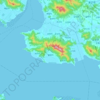
Name: Hwado-myeon topographic map, elevation, terrain.
Location: Hwado-myeon, Ganghwa-gun, Incheon, South Korea (37.56800 126.31292 37.65557 126.48848)
Average elevation: 28 m
Minimum elevation: -3 m
Maximum elevation: 448 m
Other topographic maps
Click on a map to view its topography, its elevation and its terrain.
Turczaninow Hornbeam Tree at Chamseongdan Altar
South Korea > Ganghwa-gun > Incheon > Hwado-myeon
Average elevation: 155 m