
Teramo topographic map
Interactive map
Click on the map to display elevation.
About this map
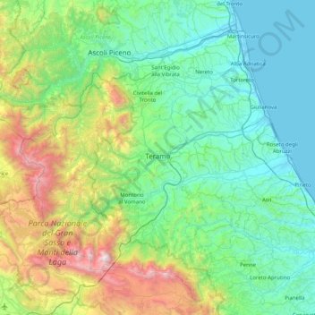
Name: Teramo topographic map, elevation, terrain.
Location: Teramo, Abruzzo, Italy (42.42112 13.34693 42.89508 14.14632)
Average elevation: 600 m
Minimum elevation: -2 m
Maximum elevation: 2,841 m
The landscape of the Province of Teramo is dominated almost entirely on the east by a large body of water with the beaches of the Adriatic sea and by the Apennine Mountains which his highest peak of Gran Sasso d'Italia westside. The province is indeed divided latitudinally by the characteristic hills and valleys rich in vineyards and olive groves that begin in the Apennines and run almost to the coast. Colline Teramane (Teramo Hills) has become a trademark and are one of the most significant areas where extra virgin olive oil and Abruzzo wines are produced.[1] Unique of the province of Teramo is the short distance between the beaches of the Adriatic sea and the 3,000-metre (9,800 ft) snowcapped Gran Sasso peaks. They can be reached within an hour from one point to the other. The peaks of the Gran Sasso rise to the west of the Province of Teramo while those of the Monti della Laga dominate its northern border. These two ridges are among the most distinctive and the most relevant of the entire Apennine Mountain range. The majestic Gran Sasso rises at its peak, the Corno Grande, to an elevation of 2,912 metres (9,554 ft) and is characterized by steep, and in places virtually inaccessible, gorges with nature reserves and protected living species. A good part of Gran Sasso and Monti della Laga National Park is nestled in the province. Calderone, the southernmost glacier in Continental European, is found nearby. In contrast to the rugged and isolated Gran Sasso area, the Monti della Laga are characterised by thick forests, shallow gorges, rolling slopes and valleys, and several spectacular waterfalls. In addition to the provincial capital, the most populous and important commercial centers include Roseto degli Abruzzi and Giulianova with populations of 25,000 and 24,000 inhabitants respectively. On the eastern portion of the province are the so-called "seven sister" beaches directly adjacent to the Adriatic Sea. These resorts are noted for one of the highest blue flag beaches density, very fine white sand and their mild and wholesome Mediterranean climates which support a rich flora of palm, pine and oleander trees. Much of the province is hilly and very few large flat plains are to be found. Running from the west to the east are a number of valley streams and rivers which eventually empty into the Adriatic Sea. The province of Teramo can easily be reached by car or bus from Rome via the A24 highway and it is also connected to the A14 highway.
Other topographic maps
Click on a map to view its topography, its elevation and its terrain.
Martinsicuro
Martinsicuro, Unione dei Comuni della Val Vibrata, Teramo, Abruzzo, 64014, Italy
Average elevation: 40 m
Pagliari
Italy > Abruzzo > Pescara > Roccamorice
Pagliari, Roccamorice, Pescara, Abruzzo, Italy
Average elevation: 623 m
Buonanotte
Italy > Abruzzo > Chieti > Vasto
Buonanotte, Vasto, Chieti, Abruzzo, 66054, Italy
Average elevation: 43 m
Fallascoso
Italy > Abruzzo > Chieti > Torricella Peligna
Fallascoso, Torricella Peligna, Chieti, Abruzzo, 66019, Italy
Average elevation: 839 m
Montebello sul Sangro
Montebello sul Sangro, Chieti, Abruzzo, Italy
Average elevation: 632 m
Villetta Barrea
Villetta Barrea, L'Aquila, Abruzzo, Italy
Average elevation: 1,595 m
Fonte Tettone
Italy > Abruzzo > Pescara > Roccamorice
Fonte Tettone, Roccamorice, Pescara, Abruzzo, Italy
Average elevation: 1,507 m
Schiavi di Abruzzo
Schiavi di Abruzzo, Chieti, Abruzzo, 66045, Italy
Average elevation: 630 m
Casale d'Abruzzo
Italy > Abruzzo > L'Aquila > Marana
Casale d'Abruzzo, Marana, Montereale, L'Aquila, Abruzzo, 67015, Italy
Average elevation: 933 m
Montorio al Vomano
Montorio al Vomano, Teramo, Abruzzo, 64046, Italy
Average elevation: 545 m
Montereale
Montereale, L'Aquila, Abruzzo, 67015, Italy
Average elevation: 1,062 m
Castel di Sangro
Castel di Sangro, L'Aquila, Abruzzo, 67031, Italy
Average elevation: 1,075 m
Cappadocia
Cappadocia, L'Aquila, Abruzzo, 67060, Italy
Average elevation: 1,215 m
Lucoli Alto
Italy > Abruzzo > L'Aquila > Collimento
Lucoli Alto, Collimento, Lucoli, L'Aquila, Abruzzo, 67045, Italy
Average elevation: 1,224 m
Casacanditella
Casacanditella, Chieti, Abruzzo, Italy
Average elevation: 250 m
Crognaleto
Crognaleto, Teramo, Abruzzo, 64043, Italy
Average elevation: 1,213 m
Prati di Tivo
Prati di Tivo, Pietracamela, Teramo, Abruzzo, 64047, Italy
Average elevation: 1,522 m
Civita d'Antino
Civita d'Antino, L'Aquila, Abruzzo, Italy
Average elevation: 930 m
Prata d'Ansidonia
Prata d'Ansidonia, L'Aquila, Abruzzo, 67020, Italy
Average elevation: 832 m
Civitella del Tronto
Civitella del Tronto, Unione dei Comuni della Val Vibrata, Teramo, Abruzzo, Italy
Average elevation: 490 m
Cugnoli
Italy > Abruzzo > Pescara > Turrivalignani
Cugnoli, Turrivalignani, Pescara, Abruzzo, 65024, Italy
Average elevation: 203 m
Carpineto della Nora
Carpineto della Nora, Pescara, Abruzzo, Italy
Average elevation: 756 m
Guardiagrele
Guardiagrele, Chieti, Abruzzo, 66016, Italy
Average elevation: 534 m
Campo di Giove
Campo di Giove, L'Aquila, Abruzzo, Italy
Average elevation: 1,291 m
Villa Piano
Italy > Abruzzo > Teramo > Isola del Gran Sasso d'Italia
Villa Piano, Isola del Gran Sasso d'Italia, Teramo, Abruzzo, 64045, Italy
Average elevation: 583 m
Sant'Eufemia a Maiella
Sant'Eufemia a Maiella, Pescara, Abruzzo, Italy
Average elevation: 1,377 m