
Aurora topographic map
Interactive map
Click on the map to display elevation.
About this map
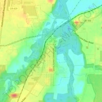
Name: Aurora topographic map, elevation, terrain.
Location: Aurora, Marion County, Oregon, United States (45.21719 -122.76550 45.24142 -122.74775)
Average elevation: 43 m
Minimum elevation: 23 m
Maximum elevation: 72 m
Other topographic maps
Click on a map to view its topography, its elevation and its terrain.
Silverton
United States > Oregon > Marion County
Silverton's elevation is between 200 and 250 feet (61 and 76 m) above mean sea level with the steep-sided, heavily-wooded Waldo Hills to the south rising an additional 200 feet (61 m). The agricultural richness of the environs is due to massive and repeated floods from prehistoric Lake Missoula in western…
Average elevation: 103 m
Salem
United States > Oregon > Marion County
Elevation within the city limits ranges from about 120 to 800 feet (37 to 244 m). Salem contains the volcanic Salem Hills in the south and is sandwiched by the 1,000 ft (300 m) Eola Hills directly to the west and the 600 ft (180 m) Waldo Hills to the east. Northern and eastern Salem are less hilly. South and…
Average elevation: 96 m