
Make a donation
Gear up for your next adventure:
As an Amazon Associate, this site earns from qualifying purchases at no extra cost to you.
Humla topographic map
Click on the map to display elevation.
Make a donation
Gear up for your next adventure:
As an Amazon Associate, this site earns from qualifying purchases at no extra cost to you.
About this map
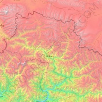
Name: Humla topographic map, elevation, terrain.
Location: Humla, Karnali Province, Nepal (29.60548 81.25622 30.44695 82.49720)
Average elevation: 4,360 m
Minimum elevation: 1,177 m
Maximum elevation: 7,625 m
Make a donation
Gear up for your next adventure:
As an Amazon Associate, this site earns from qualifying purchases at no extra cost to you.
Other topographic maps
Click on a map to view its topography, its elevation and its terrain.
Make a donation
Gear up for your next adventure:
As an Amazon Associate, this site earns from qualifying purchases at no extra cost to you.
Simikot
Nepal > Karnali Province > Humla
Lying at an altitude of just over 2,900m on a gentle slope high above the Humla Karnali River, Simikot lies on an ancient trade-cum-pilgrimage route to Mount Kailash. Mount Kailash is located in the Purang County of the Tibetan Autonomous Region, China, which borders Humla district of Nepal to the north. In…
Average elevation: 3,100 m
Make a donation
Gear up for your next adventure:
As an Amazon Associate, this site earns from qualifying purchases at no extra cost to you.
Make a donation
Gear up for your next adventure:
As an Amazon Associate, this site earns from qualifying purchases at no extra cost to you.
Make a donation
Gear up for your next adventure:
As an Amazon Associate, this site earns from qualifying purchases at no extra cost to you.
Make a donation
Gear up for your next adventure:
As an Amazon Associate, this site earns from qualifying purchases at no extra cost to you.
Make a donation
Gear up for your next adventure:
As an Amazon Associate, this site earns from qualifying purchases at no extra cost to you.
Simikot
Nepal > Karnali Province > Humla
Lying at an altitude of just over 2,900m on a gentle slope high above the Humla Karnali River, Simikot lies on an ancient trade-cum-pilgrimage route to Mount Kailash. Mount Kailash is located in the Purang County of the Tibetan Autonomous Region, China, which borders Humla district of Nepal to the north. In…
Average elevation: 3,100 m
Make a donation
Gear up for your next adventure:
As an Amazon Associate, this site earns from qualifying purchases at no extra cost to you.
Make a donation
Gear up for your next adventure:
As an Amazon Associate, this site earns from qualifying purchases at no extra cost to you.
Make a donation
Gear up for your next adventure:
As an Amazon Associate, this site earns from qualifying purchases at no extra cost to you.