Geolocate

Tauru topographic map

Click on the map to display elevation.

About this map

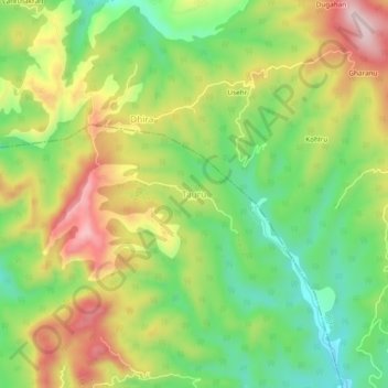
Name: Tauru topographic map, elevation, terrain.

Location: Tauru, Baroh, Kangra District, Himachal Pradesh, India (31.98355 76.37953 32.02355 76.41953)

Average elevation: 862 m

Minimum elevation: 719 m

Maximum elevation: 1,040 m

Gear up for your next adventure:

🧵Survival Paracord - Multi-purpose cordage for emergency repairs and shelters
🦯Walking Poles - Supportive poles for long-distance walking
🎒Hiking Child Carriers - Explore the outdoors with the whole family safely
🍱Food Containers - Reusable containers for outdoor meals
📢Survival Whistles - Essential safety gear for signaling for help in mountain fog

As an Amazon Associate, this site earns from qualifying purchases at no extra cost to you.