
Thank you for supporting this site ❤️
Make a donation
Make a donation
Gear up for your next adventure:
As an Amazon Associate, this site earns from qualifying purchases at no extra cost to you.
Hohenau topographic map
Click on the map to display elevation.
Thank you for supporting this site ❤️
Make a donation
Make a donation
Gear up for your next adventure:
As an Amazon Associate, this site earns from qualifying purchases at no extra cost to you.
About this map
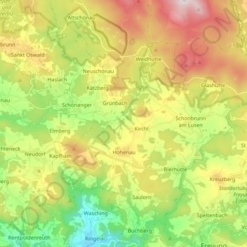
Name: Hohenau topographic map, elevation, terrain.
Location: Hohenau, Landkreis Freyung-Grafenau, Baviera, 94545, Alemania (48.80931 13.44401 48.91500 13.57674)
Average elevation: 729 m
Minimum elevation: 401 m
Maximum elevation: 1,169 m
Thank you for supporting this site ❤️
Make a donation
Make a donation
Gear up for your next adventure:
As an Amazon Associate, this site earns from qualifying purchases at no extra cost to you.