
Thank you for supporting this site ❤️
Make a donation
Make a donation
Gear up for your next adventure:
As an Amazon Associate, this site earns from qualifying purchases at no extra cost to you.
Pilcocancha topographic map
Click on the map to display elevation.
Thank you for supporting this site ❤️
Make a donation
Make a donation
Gear up for your next adventure:
As an Amazon Associate, this site earns from qualifying purchases at no extra cost to you.
About this map
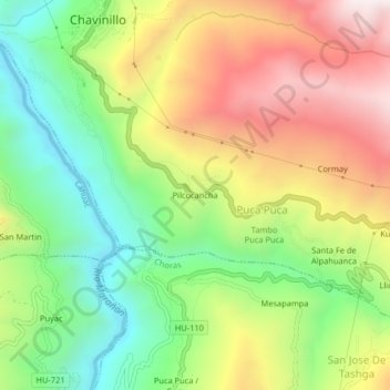
Name: Pilcocancha topographic map, elevation, terrain.
Location: Pilcocancha, Puca Puca, Chavinillo, Yarowilca, Huánuco, Perú (-9.89680 -76.61823 -9.85680 -76.57823)
Average elevation: 3,543 m
Minimum elevation: 3,122 m
Maximum elevation: 4,070 m
Thank you for supporting this site ❤️
Make a donation
Make a donation
Gear up for your next adventure:
As an Amazon Associate, this site earns from qualifying purchases at no extra cost to you.