
Arth topographic map
Interactive map
Click on the map to display elevation.
About this map
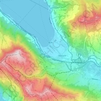
Name: Arth topographic map, elevation, terrain.
Location: Arth, Schwyz, Switzerland (47.02169 8.46486 47.09489 8.58012)
Average elevation: 865 m
Minimum elevation: 411 m
Maximum elevation: 1,791 m
Other topographic maps
Click on a map to view its topography, its elevation and its terrain.
Rigi
Switzerland > Schwyz > Schwyz > Arth
Rigi, Arth, Schwyz, 6356, Switzerland
Average elevation: 1,265 m