
Make a donation
Gear up for your next adventure:
As an Amazon Associate, this site earns from qualifying purchases at no extra cost to you.
Lembras topographic map
Click on the map to display elevation.
Make a donation
Gear up for your next adventure:
As an Amazon Associate, this site earns from qualifying purchases at no extra cost to you.
Lembras
L'altitude minimale avec 39 mètres se trouve localisée à l'extrême sud-ouest, là où le Caudeau quitte la commune et entre sur celle de Bergerac, au niveau du parc de Pombonne. L'altitude maximale avec 155 ou 163 mètres est située à l'extrême nord-est, au lieu-dit Pinceguerre, en limite des communes d'Eyraud-Crempse-Maurens et de Queyssac.
Make a donation
Gear up for your next adventure:
As an Amazon Associate, this site earns from qualifying purchases at no extra cost to you.
About this map
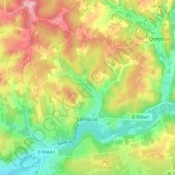
Name: Lembras topographic map, elevation, terrain.
Average elevation: 99 m
Minimum elevation: 33 m
Maximum elevation: 175 m
Make a donation
Gear up for your next adventure:
As an Amazon Associate, this site earns from qualifying purchases at no extra cost to you.