
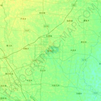
淮阳区 topographic map
Interactive map
Click on the map to display elevation.
About this map
Name: 淮阳区 topographic map, elevation, terrain.
Location: 淮阳区, 周口市, 河南省, 中国 (33.57305 114.72423 33.89305 115.04423)
Average elevation: 47 m
Minimum elevation: 40 m
Maximum elevation: 55 m
淮阳位于周口市中部,北与太康县搭界,东与鹿邑县、郸城县、沈丘县毗邻,南与项城市、商水县接壤,西与川汇区、西华县相连。淮阳全境为沙颍河北岸的冲积平原,地势平坦,由西北向东南略微倾斜,海拔在40-50米之间,以耕地为主。全县有大小河道60余条,其中主要河道14条,属淮河水系。最大的河流为沙颍河,境内长41.8公里。
Other topographic maps
Click on a map to view its topography, its elevation and its terrain.