
City of Newburgh topographic map
Interactive map
Click on the map to display elevation.
City of Newburgh
Adjacent to Newburgh, the land rises at first sharply to a bluff, where many historic structures are located, offering sweeping views of the Hudson Highlands to the south; Mount Beacon to the east and the Newburgh—Beacon Bridge to the north; then more gradually to a relatively level western half. There are some notable hills in outlying areas such as the Washington Heights section in southeast Newburgh and Mount St. Mary's at the northeast. The lowest elevation in the city is at sea level along the river; the highest is roughly 690 feet (210 m) on Snake Hill along the city's boundary with the town of New Windsor.
About this map
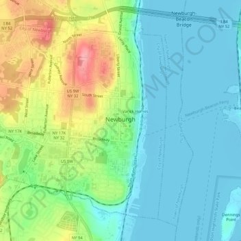
Name: City of Newburgh topographic map, elevation, terrain.
Location: City of Newburgh, Orange County, New York, United States (41.48755 -74.04862 41.51950 -74.00065)
Average elevation: 32 m
Minimum elevation: -3 m
Maximum elevation: 107 m
Other topographic maps
Click on a map to view its topography, its elevation and its terrain.
Cornwall Landing
United States > New York > Orange County > Village of Cornwall-on-Hudson
Average elevation: 74 m
Nathaniel Wetlands Inventory - R5UBH - 0.09 acres
United States > New York > Orange County
Average elevation: 138 m