Geolocate

Torrox topographic map

Click on the map to display elevation.

About this map

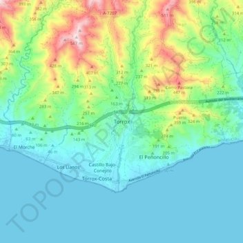
Name: Torrox topographic map, elevation, terrain.

Location: Torrox, La Axarquía, Malaga, Andalusia, 29770, Spain (36.70945 -3.99477 36.78945 -3.91477)

Average elevation: 133 m

Minimum elevation: -1 m

Maximum elevation: 553 m

Gear up for your next adventure:

🪓Outdoor Multitools - Versatile tools for hiking and camping
📻Hand-Crank Emergency Radios - Stay updated on weather warnings in remote areas
🧭Emergency Beacons - Safety beacons for remote outdoor locations
🔋Solar Power Banks - Keep your GPS and phone charged during multi-day expeditions
🗺️Ordnance Survey Maps - Official UK maps for walking and outdoor activities

As an Amazon Associate, this site earns from qualifying purchases at no extra cost to you.