
Goose Creek topographic map
Interactive map
Click on the map to display elevation.
About this map
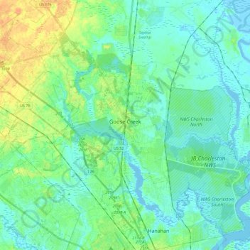
Name: Goose Creek topographic map, elevation, terrain.
Average elevation: 8 m
Minimum elevation: -5 m
Maximum elevation: 29 m
Other topographic maps
Click on a map to view its topography, its elevation and its terrain.
Dominion Hills
United States > South Carolina > Berkeley County > Hanahan
Dominion Hills, Hanahan, Berkeley County, South Carolina, 29410, United States
Average elevation: 6 m
Berkeley Hills
United States > South Carolina > Berkeley County > Hanahan
Berkeley Hills, Hanahan, Berkeley County, South Carolina, 29410, United States
Average elevation: 6 m