
Schöftland topographic map
Interactive map
Click on the map to display elevation.
About this map
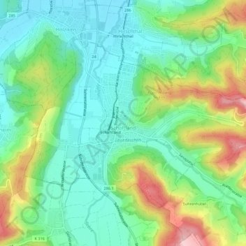
Name: Schöftland topographic map, elevation, terrain.
Location: Schöftland, Bezirk Kulm, Aargau, 5040, Schweiz (47.29345 8.03084 47.31886 8.08545)
Average elevation: 502 m
Minimum elevation: 436 m
Maximum elevation: 636 m
Other topographic maps
Click on a map to view its topography, its elevation and its terrain.
Oberkulm
Schweiz > Aargau > Bezirk Kulm
Oberkulm, Bezirk Kulm, Aargau, 5727, Schweiz
Average elevation: 555 m
Unterkulm
Schweiz > Aargau > Bezirk Kulm
Unterkulm, Bezirk Kulm, Aargau, 5726, Schweiz
Average elevation: 534 m