
Baqubah topographic map
Interactive map
Click on the map to display elevation.
About this map
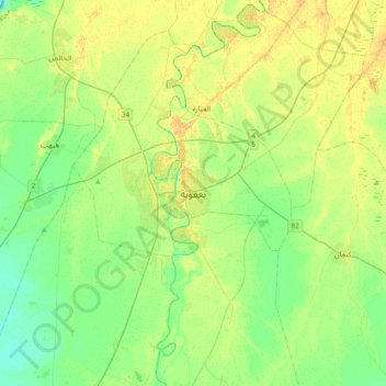
Name: Baqubah topographic map, elevation, terrain.
Average elevation: 45 m
Minimum elevation: 35 m
Maximum elevation: 56 m
Other topographic maps
Click on a map to view its topography, its elevation and its terrain.
Nahr Ibrahim
Iraq > Diyala Governorate > Qarayat Faris Tarish
Nahr Ibrahim, Qarayat Faris Tarish, Kan'an Subdistrict, Ba'quba District, Diyala Governorate, Iraq
Average elevation: 45 m
Jalawla Subdistrict
Jalawla Subdistrict, Khanaqin District, Diyala Governorate, Iraq
Average elevation: 140 m
Ismail al Iss
Ismail al Iss, Al-Miqdadiyah Central Subdistrict, Al-Miqdadiyah District, Diyala Governorate, Iraq
Average elevation: 65 m
David the write off
David the write off, Mandali Subdistrict, Balad Ruz District, Diyala Governorate, Iraq
Average elevation: 46 m
Eshnunna
Iraq > Diyala Governorate > Arab Muhammad ar Rashid
Eshnunna, Arab Muhammad ar Rashid, Buhriz Subdistrict, Ba'quba District, Diyala Governorate, Iraq
Average elevation: 41 m
Jabur
Iraq > Diyala Governorate > Muhammad Hanni > Jabur
Jabur, Muhammad Hanni, Al-Sadiyah Subdsitrict, Khanaqin District, Diyala Governorate, Iraq
Average elevation: 111 m
Raml
Iraq > Diyala Governorate > Hajj Humayid
Raml, Hajj Humayid, Sadd Al-Adhaim Subdsitrict, Al-Khalis District, Diyala Governorate, Iraq
Average elevation: 69 m