
Baile Mòr topographic map
Interactive map
Click on the map to display elevation.
About this map
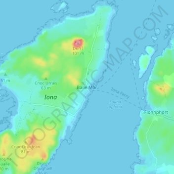
Name: Baile Mòr topographic map, elevation, terrain.
Average elevation: 12 m
Minimum elevation: -1 m
Maximum elevation: 96 m
Other topographic maps
Click on a map to view its topography, its elevation and its terrain.
Island of Danna
Vereinigtes Königreich > Schottland > Argyll and Bute
Island of Danna, Argyll and Bute, Schottland, Vereinigtes Königreich
Average elevation: 9 m
Foreland
Vereinigtes Königreich > Schottland > Argyll and Bute
Foreland, Argyll and Bute, Schottland, PA49 7UU, Vereinigtes Königreich
Average elevation: 32 m
Oban
Vereinigtes Königreich > Schottland > Argyll and Bute
Oban, Argyll and Bute, Schottland, PA34 5PZ, Vereinigtes Königreich
Average elevation: 47 m
Appin
Vereinigtes Königreich > Schottland > Argyll and Bute
Appin, Argyll and Bute, Schottland, PA38 4DB, Vereinigtes Königreich
Average elevation: 93 m
North Connel
Vereinigtes Königreich > Schottland > Argyll and Bute
North Connel, Argyll and Bute, Schottland, PA37 1PL, Vereinigtes Königreich
Average elevation: 19 m
Garelochhead
Vereinigtes Königreich > Schottland > Argyll and Bute
Garelochhead, Argyll and Bute, Schottland, G84 0AY, Vereinigtes Königreich
Average elevation: 110 m