
Herz topographic map
Interactive map
Click on the map to display elevation.
About this map
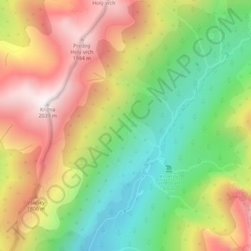
Name: Herz topographic map, elevation, terrain.
Average elevation: 1,552 m
Minimum elevation: 1,146 m
Maximum elevation: 2,013 m
Other topographic maps
Click on a map to view its topography, its elevation and its terrain.
Lomnitzer Spitze
Slowakei > Eperieser Landschaftsverband > Bezirk Deutschendorf > Hohe Tatra
Lange wurde in der Zips der Vater als höchster Punkt des Schneegebirge, wie die Tatra zeitgenössisch genannt wurde und galt als unbesteigbar, im Gegensatz zur nahen Kesmarker Spitze. Bezüglich der Höhe hatte die Lomnitzer Spitze einen ähnlichen Status wie der Kriváň in der Liptau oder die Eistaler…
Average elevation: 2,052 m
Roter Turm
Slowakei > Eperieser Landschaftsverband > Bezirk Deutschendorf > Hohe Tatra
Average elevation: 2,082 m