
Natanz County topographic map
Interactive map
Click on the map to display elevation.
About this map
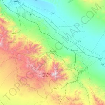
Name: Natanz County topographic map, elevation, terrain.
Location: Natanz County, Isfahan Province, 87661-37751, Iran (33.25193 51.41826 33.96827 52.34117)
Average elevation: 1,710 m
Minimum elevation: 921 m
Maximum elevation: 3,791 m
Other topographic maps
Click on a map to view its topography, its elevation and its terrain.
Zagros Mountains
Iran > Isfahan Province > Semirom County > Padena-ye Vosta RD
Average elevation: 3,846 m
Natanz
Iran > Isfahan Province > Natanz County > دهستان کرکس
Natanz is located 120 km northeast of Isfahan and on the main north-south highway of Iran. Its altitude is 1666 meters above sea level. The distance between Tehran and Natanz is 326 km, and it takes about 4 hours by car. The Karkas mountain chain (Kuh-e Karkas) (meaning mountain of vultures), at an elevation…
Average elevation: 1,775 m
Zagros Mountains
Iran > Isfahan Province > Semirom County > Padena-ye Vosta RD
Average elevation: 3,846 m
شهرک علمی و تحقیقاتی دانشگاه صنعتی اصفهان همایون شهر
Iran > Isfahan Province > شهرک علمی و تحقیقاتی دانشگاه صنعتی اصفهان همایون شهر > خمینی شهر
Average elevation: 1,705 m
Chamgordan
Iran > Isfahan Province > Lenjan County > دهستان خرم رود > Chamgordan
Average elevation: 1,727 m