
Arfurt topographic map
Interactive map
Click on the map to display elevation.
About this map
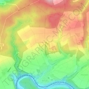
Name: Arfurt topographic map, elevation, terrain.
Location: Arfurt, Runkel, Landkreis Limburg-Weilburg, Hessen, Deutschland (50.40428 8.18193 50.43583 8.21850)
Average elevation: 213 m
Minimum elevation: 117 m
Maximum elevation: 305 m
Der Ort selbst liegt auf rund 160 Metern Höhe. Unmittelbar an seinem Südostrand fällt das Gelände bis zur Lahn rund 50 Meter steil ab. Im Westen des Orts gestaltet sich dieser Übergang wesentlich sanfter, so dass auch der Hang bis zum Lahnufer hinab bebaut ist.
Other topographic maps
Click on a map to view its topography, its elevation and its terrain.
Dehrn
Deutschland > Hessen > Landkreis Limburg-Weilburg > Runkel
Dehrn, Runkel, Landkreis Limburg-Weilburg, Hessen, Deutschland
Average elevation: 172 m
Eschenau
Deutschland > Hessen > Landkreis Limburg-Weilburg > Runkel
Eschenau, Runkel, Landkreis Limburg-Weilburg, Hessen, Deutschland
Average elevation: 209 m
Steeden
Deutschland > Hessen > Landkreis Limburg-Weilburg > Runkel > Steeden
Steeden, Runkel, Landkreis Limburg-Weilburg, Hessen, 65594, Deutschland
Average elevation: 158 m