
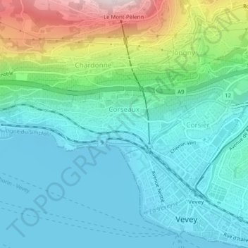
Corseaux topographic map
Interactive map
Click on the map to display elevation.
About this map
Name: Corseaux topographic map, elevation, terrain.
Average elevation: 494 m
Minimum elevation: 367 m
Maximum elevation: 909 m
Other topographic maps
Click on a map to view its topography, its elevation and its terrain.
L'Étivaz
Schweiz > Waadt > District de la Riviera-Pays-d’Enhaut > Château-d'Oex
L'Étivaz, Château-d'Oex, District de la Riviera-Pays-d’Enhaut, Waadt, 1660, Schweiz
Average elevation: 1,492 m
Rougemont
Schweiz > Waadt > District de la Riviera-Pays-d’Enhaut
Rougemont, District de la Riviera-Pays-d’Enhaut, Waadt, 1659, Schweiz
Average elevation: 1,487 m
Rochers de Naye
Schweiz > Waadt > District de la Riviera-Pays-d’Enhaut > Veytaux
Rochers de Naye, Veytaux, District de la Riviera-Pays-d’Enhaut, Waadt, 1820, Schweiz
Average elevation: 1,570 m
Vevey
Schweiz > Waadt > District de la Riviera-Pays-d’Enhaut
Vevey, District de la Riviera-Pays-d’Enhaut, Waadt, 1800, Schweiz
Average elevation: 448 m