
Make a donation
Gear up for your next adventure:
As an Amazon Associate, this site earns from qualifying purchases at no extra cost to you.
Stratford topographic map
Click on the map to display elevation.
Make a donation
Gear up for your next adventure:
As an Amazon Associate, this site earns from qualifying purchases at no extra cost to you.
Stratford
According to the United States Census Bureau, the town has a total area of 19.9 square miles (52 km2), of which 17.6 square miles (46 km2) is land and 2.3 square miles (6.0 km2), or 11.52%, is water. Stratford has a minimum elevation of zero feet above sea level along its coastline, with a maximum altitude of 295 feet (90 m) near its northern border, and an average elevation of 23 feet (7.0 m).
Make a donation
Gear up for your next adventure:
As an Amazon Associate, this site earns from qualifying purchases at no extra cost to you.
About this map
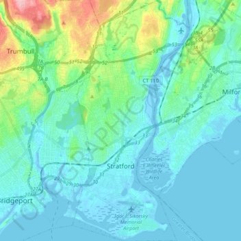
Name: Stratford topographic map, elevation, terrain.
Average elevation: 25 m
Minimum elevation: -8 m
Maximum elevation: 149 m
Make a donation
Gear up for your next adventure:
As an Amazon Associate, this site earns from qualifying purchases at no extra cost to you.
Other topographic maps
Click on a map to view its topography, its elevation and its terrain.
Oronoque
United States > Connecticut > Greater Bridgeport Planning Region > Stratford
Average elevation: 37 m
Southport
United States > Connecticut > Greater Bridgeport Planning Region > Fairfield
Average elevation: 11 m
Greenfield Hill
United States > Connecticut > Greater Bridgeport Planning Region > Fairfield
Average elevation: 53 m
Long Hill
United States > Connecticut > Greater Bridgeport Planning Region > Trumbull
Average elevation: 117 m
Make a donation
Gear up for your next adventure:
As an Amazon Associate, this site earns from qualifying purchases at no extra cost to you.
Barn Hill
United States > Connecticut > Greater Bridgeport Planning Region > Monroe
Average elevation: 146 m
Long Hill
United States > Connecticut > Greater Bridgeport Planning Region > Trumbull
Average elevation: 117 m
Powells Hill
United States > Connecticut > Greater Bridgeport Planning Region > Easton
Average elevation: 87 m
Stratfield
United States > Connecticut > Greater Bridgeport Planning Region > Fairfield
Average elevation: 53 m
Make a donation
Gear up for your next adventure:
As an Amazon Associate, this site earns from qualifying purchases at no extra cost to you.
Lordship Beach
United States > Connecticut > Greater Bridgeport Planning Region > Stratford > Lordship
Average elevation: 1 m