Geolocate

Hewitt topographic map

Interactive map

Click on the map to display elevation.

About this map

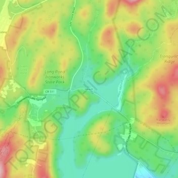
Name: Hewitt topographic map, elevation, terrain.

Location: Hewitt, West Milford, Passaic County, New Jersey, 10979, United States (41.12171 -74.33019 41.16171 -74.29019)

Average elevation: 185 m

Minimum elevation: 91 m

Maximum elevation: 306 m

Other topographic maps

Click on a map to view its topography, its elevation and its terrain.

Upper Macopin

United States > New Jersey > Passaic County > West Milford

Upper Macopin, West Milford, Passaic County, New Jersey, 07480, United States

Average elevation: 298 m

Upper Greenwood Lake

United States > New Jersey > Passaic County > West Milford

Upper Greenwood Lake, West Milford, Passaic County, New Jersey, 07421, United States

Average elevation: 360 m