
Corno Grande - Vetta Occidentale topographic map
Interactive map
Click on the map to display elevation.
About this map
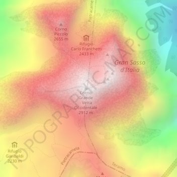
Name: Corno Grande - Vetta Occidentale topographic map, elevation, terrain.
Average elevation: 2,222 m
Minimum elevation: 1,289 m
Maximum elevation: 2,872 m
Other topographic maps
Click on a map to view its topography, its elevation and its terrain.
Gran Sasso d'Italia
Italia > Abruzzo > Teramo > Isola del Gran Sasso d'Italia
Gran Sasso d'Italia, Isola del Gran Sasso d'Italia, Teramo, Abruzzo, Italia
Average elevation: 1,976 m