
Bijie topographic map
Interactive map
Click on the map to display elevation.
About this map
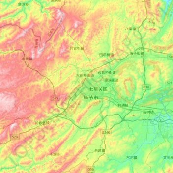
Name: Bijie topographic map, elevation, terrain.
Location: Bijie, Qixingguan, Bijie, Guizhou, 551700, China (27.12586 105.12660 27.44586 105.44660)
Average elevation: 1,651 m
Minimum elevation: 1,320 m
Maximum elevation: 2,158 m
Bijie borders Zunyi to the east, Anshun and Liupanshui to the south, Zhaotong and Qujing (Yunnan) to the west, and Luzhou (Sichuan) to the north. It spans latitude 26°21′−27°46′ N and longitude 105°36′−106°43′ E, and is marked heavily by the presence of the Wumeng Mountains (乌蒙山) as well as karst topography. The Wu, Beipan, and Chishui Rivers are the most important rivers that originate here. The highest elevation is Jiucaiping (韭菜坪), at 2,900.6 m (9,516 ft), on the border of Hezhang and Weining counties.