
Thank you for supporting this site ❤️
Make a donation
Make a donation
Gear up for your next adventure:
As an Amazon Associate, this site earns from qualifying purchases at no extra cost to you.
Tala topographic map
Click on the map to display elevation.
Thank you for supporting this site ❤️
Make a donation
Make a donation
Gear up for your next adventure:
As an Amazon Associate, this site earns from qualifying purchases at no extra cost to you.
About this map
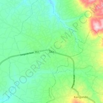
Name: Tala topographic map, elevation, terrain.
Location: Tala, Tala ward, Matungulu, Machakos County, Kenya (-1.30814 37.28439 -1.22814 37.36439)
Average elevation: 1,539 m
Minimum elevation: 1,441 m
Maximum elevation: 1,792 m
Thank you for supporting this site ❤️
Make a donation
Make a donation
Gear up for your next adventure:
As an Amazon Associate, this site earns from qualifying purchases at no extra cost to you.