
Crans-Montana topographic map
Interactive map
Click on the map to display elevation.
About this map
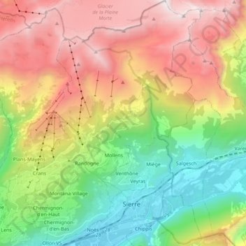
Name: Crans-Montana topographic map, elevation, terrain.
Location: Crans-Montana, Sierre, Wallis, 3960, Switzerland (46.27218 7.45877 46.38897 7.58017)
Average elevation: 1,660 m
Minimum elevation: 508 m
Maximum elevation: 3,155 m
The resort is located in the heart of the Swiss Alps in the French-speaking part of the canton of Valais. It is located on a plateau above Sierre at an elevation of about 1,500 m (4,920 ft) above sea level, allowing good view over the Valais Alps and Weisshorn in particular. The resort is a fusion of the two centers of Crans and Montana and belongs to 6 municipalities (Chermignon, Icogne, Lens, Mollens, Montana and Randogne).
Other topographic maps
Click on a map to view its topography, its elevation and its terrain.
Lac de Chermignon
Switzerland > Wallis > Sierre > Plans-Mayens
Lac de Chermignon, Plans-Mayens, Lens, Sierre, Wallis, 3960, Switzerland
Average elevation: 1,548 m
Lac de Châteaupré
Switzerland > Wallis > Sierre > Anniviers
Lac de Châteaupré, Anniviers, Sierre, Wallis, 3961, Switzerland
Average elevation: 2,646 m
Zinal
Switzerland > Wallis > Sierre > Anniviers
Zinal, Anniviers, Sierre, Wallis, 3961, Switzerland
Average elevation: 2,209 m
Chandolin
Switzerland > Wallis > Sierre > Anniviers
Chandolin, Anniviers, Sierre, Wallis, 3961, Switzerland
Average elevation: 1,901 m
Randogne
Switzerland > Wallis > Sierre > Crans-Montana
Randogne, Crans-Montana, Sierre, Wallis, 3960, Switzerland
Average elevation: 1,614 m
Couronne de Bréona
Switzerland > Wallis > Sierre > Anniviers
Couronne de Bréona, Anniviers, Sierre, Wallis, 3961, Switzerland
Average elevation: 2,720 m