
Thank you for supporting this site ❤️
Make a donation
Make a donation
Gear up for your next adventure:
As an Amazon Associate, this site earns from qualifying purchases at no extra cost to you.
Lanreath topographic map
Click on the map to display elevation.
Thank you for supporting this site ❤️
Make a donation
Make a donation
Gear up for your next adventure:
As an Amazon Associate, this site earns from qualifying purchases at no extra cost to you.
About this map
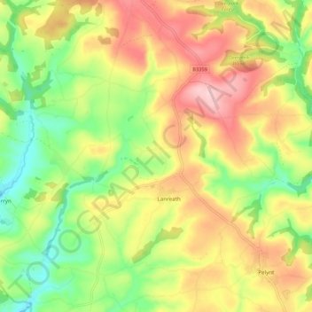
Name: Lanreath topographic map, elevation, terrain.
Location: Lanreath, Cornwall, England, United Kingdom (50.35884 -4.60159 50.42704 -4.51330)
Average elevation: 101 m
Minimum elevation: 2 m
Maximum elevation: 211 m
Cornwall trails, hiking, mountain biking, running and outdoor activities
Thank you for supporting this site ❤️
Make a donation
Make a donation
Gear up for your next adventure:
As an Amazon Associate, this site earns from qualifying purchases at no extra cost to you.
Other topographic maps
Click on a map to view its topography, its elevation and its terrain.
Battle of Braddock Down
United Kingdom > England > Cornwall > Lanreath > Bocaddon
Average elevation: 138 m