Geolocate

Clausnitz topographic map

Click on the map to display elevation.

About this map

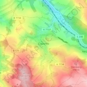
Name: Clausnitz topographic map, elevation, terrain.

Location: Clausnitz, Rechenberg-Bienenmühle, Mittelsachsen, Saxony, 09623, Germany (50.72366 13.46966 50.76366 13.50966)

Average elevation: 609 m

Minimum elevation: 501 m

Maximum elevation: 718 m

Other topographic maps

Click on a map to view its topography, its elevation and its terrain.

Freiberg

Germany > Saxony > Mittelsachsen

The town lies on the northern declivity of the Ore Mountains, with the majority of the borough west of the Eastern or Freiberger Mulde river. Parts of the town are nestled in the valleys of Münzbach and Goldbach streams. Its centre has an altitude of about 412 m above sea level (NHN) (at the railway station).…

Average elevation: 405 m

Hainichen

Germany > Saxony > Mittelsachsen

Average elevation: 341 m

Waldheim

Germany > Saxony > Mittelsachsen

Average elevation: 261 m

Hartha

Germany > Saxony > Mittelsachsen

Average elevation: 244 m

Sayda

Germany > Saxony > Mittelsachsen

Average elevation: 643 m

Frankenberg/Sachsen

Germany > Saxony > Mittelsachsen

Average elevation: 326 m

Flöha

Germany > Saxony > Mittelsachsen

Average elevation: 359 m

Frauenstein

Germany > Saxony > Mittelsachsen

Average elevation: 594 m

Mittweida

Germany > Saxony > Mittelsachsen

Average elevation: 295 m

Gear up for your next adventure:

🧢Hiking Hats - Sun and weather protection for outdoor walks
🧺Ultralight Dry Bags - Organize and waterproof your gear inside your rucksack
Insulated Travel Mugs - Keep drinks hot while surveying the landscape from a summit
📸Action Camera Chest Mounts - Record your ascent following topographic paths hands-free
🧤Hiking Gloves - Warm and durable gloves for cold-weather walks

As an Amazon Associate, this site earns from qualifying purchases at no extra cost to you.