Geolocate

Acoria topographic map

Click on the map to display elevation.

About this map
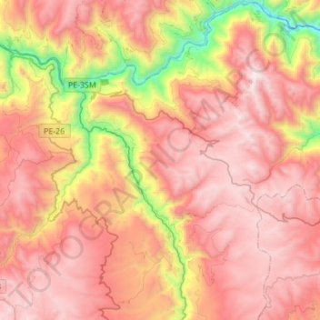
Name: Acoria topographic map, elevation, terrain.

Location: Acoria, Province of Huancavelica, Huancavelica, Peru (-12.72744 -74.95739 -12.46353 -74.68380)

Average elevation: 3,885 m

Minimum elevation: 2,624 m

Maximum elevation: 4,731 m

Other topographic maps

Click on a map to view its topography, its elevation and its terrain.
Caymo

Peru > Huancavelica > Salcabamba

Average elevation: 3,119 m

Palermo

Peru > Huancavelica > El Carmen

Average elevation: 3,708 m

Yanacocha

Peru > Huancavelica

Average elevation: 3,468 m

Gear up for your next adventure:

🎒Replacement Sternum Straps - Repair parts for hiking rucksacks
🧰First Aid Kits - Essential safety kits for outdoor activities
🔪Outdoor Multi-Tools - Versatile tools for gear repairs and food prep in the wild
🕶️Polarized Sunglasses - Reduces glare from snow and water when reading terrain
🔦LED Camping Lanterns - Illumination for reading maps inside your tent at night

As an Amazon Associate, this site earns from qualifying purchases at no extra cost to you.