Geolocate

Beatriz topographic map

Click on the map to display elevation.

About this map

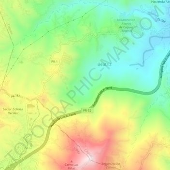
Name: Beatriz topographic map, elevation, terrain.

Location: Beatriz, Caguas, Puerto Rico, United States (18.14986 -66.10514 18.19517 -66.05763)

Average elevation: 362 m

Minimum elevation: 110 m

Maximum elevation: 733 m

Other topographic maps

Click on a map to view its topography, its elevation and its terrain.

Sector Pradera

United States > Puerto Rico > Caguas > Caguas

Average elevation: 255 m

Gear up for your next adventure:

🧼Technical Clothing Wash - Special soap to clean and restore waterproof membranes
❄️Walking Crampons - Added traction for icy slopes and winter peak bagging
🛌Sleeping Mats - Insulated mats for comfortable outdoor sleeping
🦯Walking Poles - Supportive poles for long-distance walking
GPS Outdoor Watches - Watches with GPS tracking for hiking and exploration

As an Amazon Associate, this site earns from qualifying purchases at no extra cost to you.