Geolocate

Wirogunan topographic map

Click on the map to display elevation.

About this map

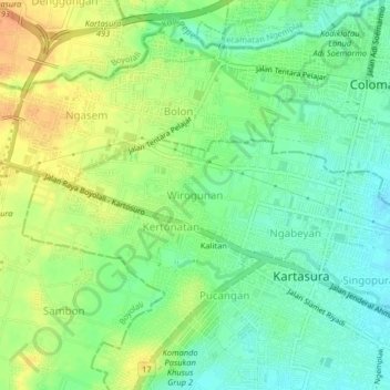
Name: Wirogunan topographic map, elevation, terrain.

Location: Wirogunan, Sukoharjo, Central Java, Java, 57165, Indonesia (-7.56378 110.70952 -7.52378 110.74952)

Average elevation: 133 m

Minimum elevation: 116 m

Maximum elevation: 154 m

Other topographic maps

Click on a map to view its topography, its elevation and its terrain.

Bulu

Indonesia > Central Java > Sukoharjo

Average elevation: 126 m

Puron

Indonesia > Central Java > Sukoharjo

Average elevation: 128 m

Lapangan Makamhaji

Indonesia > Central Java > Sukoharjo > Gentan > Kuyudan

Average elevation: 104 m

Waduk Mulur

Indonesia > Central Java > Sukoharjo > Bendosari

Average elevation: 114 m

Karangasem

Indonesia > Central Java > Sukoharjo > Karangasem

Average elevation: 115 m

Gear up for your next adventure:

🎒Hiking Backpacks - Comfortable backpacks for day hikes and multi-day treks
🔦Keychain LED Torches - Emergency backup light for finding gear in your pack
👟Men's Trail Running Shoes - Lightweight grip for fast movement over topographic contours
🔪Outdoor Multi-Tools - Versatile tools for gear repairs and food prep in the wild
👖Packable Overtrousers - Quick-deploy rain protection for legs in sudden storms

As an Amazon Associate, this site earns from qualifying purchases at no extra cost to you.