Geolocate

Udaypur topographic map

Click on the map to display elevation.

About this map

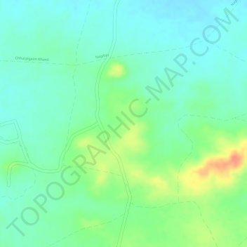
Name: Udaypur topographic map, elevation, terrain.

Location: Udaypur, Gogaon Tahsil, Khargone, Madhya Pradesh, India (21.74718 75.66489 21.76551 75.69088)

Average elevation: 298 m

Minimum elevation: 281 m

Maximum elevation: 331 m

Gear up for your next adventure:

❄️Walking Crampons - Added traction for icy slopes and winter peak bagging
🧊Insulated Flasks - Keeps drinks hot or cold during hikes
🧷Tenacious Repair Tape - Instant fix for torn tents, jackets, or dry bags
📍Handheld GPS Navigators - Reliable satellite navigation for hiking and off-road exploration
🔋Lithium AA Batteries - Long-lasting power that performs well in cold mountain weather

As an Amazon Associate, this site earns from qualifying purchases at no extra cost to you.