
Make a donation
Gear up for your next adventure:
As an Amazon Associate, this site earns from qualifying purchases at no extra cost to you.
Pantelhó topographic map
Click on the map to display elevation.
Make a donation
Gear up for your next adventure:
As an Amazon Associate, this site earns from qualifying purchases at no extra cost to you.
Pantelhó
Se ubica en la Región Socioeconómica V ALTOS TSOTSIL TSELTAL. Limita al norte con Simojovel y Yajalón, al este con el municipio de Chilón y Sitalá, al sur con el municipio de San Juan Cancuc y el municipio de Chenalhó y al oeste con el municipio de Chenalhó, municipio de Chalchihuitán y Simojovel. Las coordenadas de la cabecera municipal son: 17°00'20" de latitud norte y 92°28'08" de longitud oeste y se ubica a una altitud de 1056 m s. n. m. y con una superficie territorial de 192,4 km² ocupa el 0.26% del territorio estatal.
Make a donation
Gear up for your next adventure:
As an Amazon Associate, this site earns from qualifying purchases at no extra cost to you.
About this map
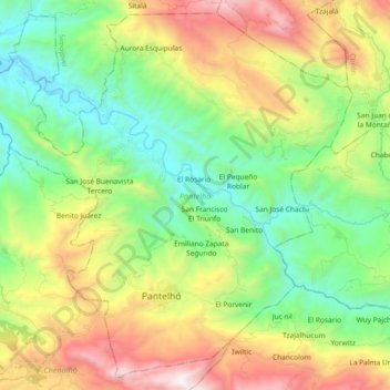
Name: Pantelhó topographic map, elevation, terrain.
Location: Pantelhó, Chiapas, México (16.96823 -92.56518 17.13322 -92.38075)
Average elevation: 1,021 m
Minimum elevation: 333 m
Maximum elevation: 2,244 m
Make a donation
Gear up for your next adventure:
As an Amazon Associate, this site earns from qualifying purchases at no extra cost to you.
Other topographic maps
Click on a map to view its topography, its elevation and its terrain.
Make a donation
Gear up for your next adventure:
As an Amazon Associate, this site earns from qualifying purchases at no extra cost to you.
Make a donation
Gear up for your next adventure:
As an Amazon Associate, this site earns from qualifying purchases at no extra cost to you.