
Western Brook Pond topographic map
Interactive map
Click on the map to display elevation.
About this map
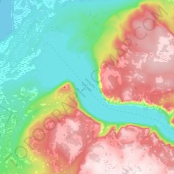
Name: Western Brook Pond topographic map, elevation, terrain.
Average elevation: 337 m
Minimum elevation: 0 m
Maximum elevation: 796 m
Other topographic maps
Click on a map to view its topography, its elevation and its terrain.
Goose Bay
Canada > Newfoundland en Labrador > Happy Valley-Goose Bay
Goose Bay, Happy Valley-Goose Bay, Labrador, Newfoundland en Labrador, Canada
Average elevation: 28 m
Newfoundland
Canada > Newfoundland en Labrador
Newfoundland, Newfoundland en Labrador, Canada
Average elevation: 87 m
The Block
Canada > Newfoundland en Labrador
The Block, Newfoundland, Newfoundland en Labrador, Canada
Average elevation: 23 m
Corner Brook
Canada > Newfoundland en Labrador > Corner Brook
Corner Brook, Newfoundland, Newfoundland en Labrador, Canada
Average elevation: 236 m
St. John's
Canada > Newfoundland en Labrador > St. John's
St. John's, Newfoundland, Newfoundland en Labrador, A1C 2G4, Canada
Average elevation: 66 m
Norris Point
Canada > Newfoundland en Labrador > Norris Point
Norris Point, Newfoundland en Labrador, A0K 3V0, Canada
Average elevation: 86 m
Port au Port Peninsula
Canada > Newfoundland en Labrador > Lourdes
Port au Port Peninsula, Highway 463, Lourdes, Newfoundland en Labrador, Canada
Average elevation: 142 m