
Stepantsminda topographic map
Click on the map to display elevation.
Stepantsminda
The town is located along the banks of the Terek River, 157 kilometers (98 mi) to the north of Tbilisi at an elevation of 1,740 meters (5,710 feet) above sea level. Stepantsminda’s climate is moderately humid with relatively dry, cold winters and long and cool summers. The average annual temperature is 4.9 degrees Celsius. January is the coldest month with an average temperature of -5.2 degrees Celsius while July is the warmest month with an average temperature of 14.4 degrees Celsius. The absolute minimum recorded temperature is -34 degrees Celsius and the absolute maximum is 32 degrees Celsius. Stepantsminda’s average annual precipitation is 790 mm. (31.1 inches). The town is dominated by large mountains on all sides. The most notable mountain of the region, Mount Kazbek of the Lateral Range, lies immediately to the west of town. The second most prominent peak, Mt. Shani, rises to an elevation of 4,451 meters (14,600 feet) above sea level, 9 kilometers to the east of Stepantsminda. The town is located 10 kilometers to the south of the famous Darial Gorge.
About this map
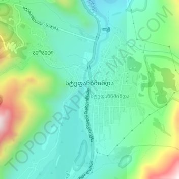
Name: Stepantsminda topographic map, elevation, terrain.
Average elevation: 1,851 m
Minimum elevation: 1,668 m
Maximum elevation: 2,334 m
Other topographic maps
Click on a map to view its topography, its elevation and its terrain.
Gudauri
Georgia > Mtskheta-Mtianeti > Kazbegi Municipality
Gudauri (Georgian: გუდაური) is a ski resort located on the south-facing plateau of The Greater Caucasus Mountain Range in Georgia. The resort is situated in the Stepantsminda District, along the Georgian Military Highway near the Jvari Pass, at an elevation of 2,200 meters (7,200 ft.) above sea…
Average elevation: 2,161 m
Darial Gorge
Georgia > Mtskheta-Mtianeti > Kazbegi Municipality
The Russian fort, Darial, which guarded this section of the Georgian Military Road, was built at the northern end of the gorge, at an altitude of 1,447 metres (4,747 ft).
Average elevation: 1,783 m
Mtskheta — Stepantsminda — Larsi
Georgia > Mtskheta-Mtianeti > Kazbegi Municipality > Gudauri
Average elevation: 2,284 m
Gudauri
Georgia > Mtskheta-Mtianeti > Kazbegi Municipality
Gudauri (Georgian: გუდაური) is a ski resort located on the south-facing plateau of The Greater Caucasus Mountain Range in Georgia. The resort is situated in the Kazbegi Municipality, along the Georgian Military Highway near the Jvari Pass, at an elevation of 2,200 meters (7,200 ft.) above sea…
Average elevation: 2,161 m
Gudauri
Georgia > Mtskheta-Mtianeti > Kazbegi Municipality
Gudauri (Georgian: გუდაური) is a ski resort located on the south-facing plateau of The Greater Caucasus Mountain Range in Georgia. The resort is situated in the Stepantsminda District, along the Georgian Military Highway near the Jvari Pass, at an elevation of 2,200 meters (7,200 ft.) above sea…
Average elevation: 2,161 m
Shan
Georgia > Mtskheta-Mtianeti > Kazbegi Municipality
Mt. Shani (Ingush: Шанлоам, lit. ''icy mountain''; Georgian: შანი; Russian: Шан) also known as Shan and Shanloam is a mountain in the Caucasus. It has an elevation of 4,451 metres (14,603 ft) and is on the international border between Georgia and Ingushetia, Russia.
Average elevation: 3,620 m
Gudauri
Georgia > Mtskheta-Mtianeti > Kazbegi Municipality
Gudauri (Georgian: გუდაური) is a ski resort located on the south-facing plateau of The Greater Caucasus Mountain Range in Georgia. The resort is situated in the Kazbegi Municipality, along the Georgian Military Highway near the Jvari Pass, at an elevation of 2,200 meters (7,200 ft.) above sea…
Average elevation: 2,161 m
Gudauri
Georgia > Mtskheta-Mtianeti > Kazbegi Municipality
Gudauri (Georgian: გუდაური) is a ski resort located on the south-facing plateau of The Greater Caucasus Mountain Range in Georgia. The resort is situated in the Stepantsminda District, along the Georgian Military Highway near the Jvari Pass, at an elevation of 2,200 meters (7,200 ft.) above sea…
Average elevation: 2,161 m