Indro topographic map
Interactive map
Click on the map to display elevation.
About this map
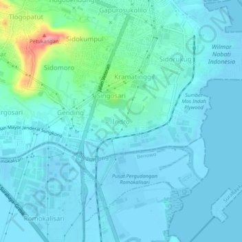
Name: Indro topographic map, elevation, terrain.
Location: Indro, Gresik, East Java, Java, 57378, Indonesia (-7.20893 112.63227 -7.16893 112.67227)
Average elevation: 15 m
Minimum elevation: -7 m
Maximum elevation: 109 m
Other topographic maps
Click on a map to view its topography, its elevation and its terrain.
Gunung Limas
Indonesia > East Java > Gresik
Gunung Limas, Gresik, East Java, Indonesia
Average elevation: 64 m
Sembungan Kidul
Indonesia > East Java > Gresik > Sembungan Kidul
Sembungan Kidul, Gresik, East Java, 61152, Indonesia
Average elevation: 7 m