
Make a donation
Gear up for your next adventure:
As an Amazon Associate, this site earns from qualifying purchases at no extra cost to you.
Solidaridad topographic map
Click on the map to display elevation.
Make a donation
Gear up for your next adventure:
As an Amazon Associate, this site earns from qualifying purchases at no extra cost to you.
About this map
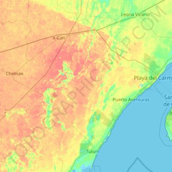
Name: Solidaridad topographic map, elevation, terrain.
Location: Solidaridad, Quintana Roo, Mexico (20.35686 -87.96274 20.81206 -86.92063)
Average elevation: 13 m
Minimum elevation: -3 m
Maximum elevation: 31 m
Make a donation
Gear up for your next adventure:
As an Amazon Associate, this site earns from qualifying purchases at no extra cost to you.
Other topographic maps
Click on a map to view its topography, its elevation and its terrain.
Make a donation
Gear up for your next adventure:
As an Amazon Associate, this site earns from qualifying purchases at no extra cost to you.
Presidente Juárez
Mexico > Quintana Roo > Felipe Carrillo Puerto > Presidente Juárez
Average elevation: 23 m