
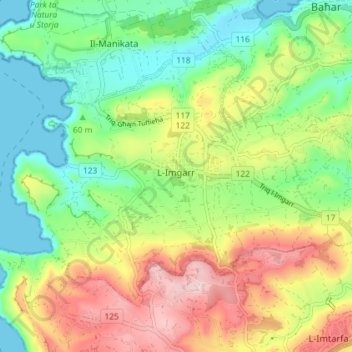
L-Imġarr topographic map
Interactive map
Click on the map to display elevation.
About this map
Name: L-Imġarr topographic map, elevation, terrain.
Location: L-Imġarr, Northern Region, MGR 1502, Malta (35.89676 14.33252 35.94068 14.40480)
Average elevation: 96 m
Minimum elevation: 0 m
Maximum elevation: 239 m
Other topographic maps
Click on a map to view its topography, its elevation and its terrain.
Baħar iċ-Ċagħaq
Malta > Northern Region > Naxxar > Baħar iċ-Ċagħaq
Baħar iċ-Ċagħaq, Naxxar, Northern Region, NXR 9038, Malta
Average elevation: 39 m
Saint Paul's Bay
Saint Paul's Bay, Northern Region, Malta
Average elevation: 56 m
Qawra
Malta > Northern Region > Saint Paul's Bay
Qawra, Saint Paul's Bay, Northern Region, SPB 1902, Malta
Average elevation: 15 m
Buġibba
Malta > Northern Region > Saint Paul's Bay > Buġibba
Buġibba, Saint Paul's Bay, Northern Region, SPB 3015, Malta
Average elevation: 26 m