
Siebenborn topographic map
Interactive map
Click on the map to display elevation.
About this map
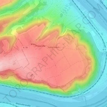
Name: Siebenborn topographic map, elevation, terrain.
Average elevation: 147 m
Minimum elevation: 67 m
Maximum elevation: 245 m
Other topographic maps
Click on a map to view its topography, its elevation and its terrain.
Brey
Deutschland > Rheinland-Pfalz > Landkreis Mayen-Koblenz > Brey
Brey, Rhein-Mosel, Landkreis Mayen-Koblenz, Rheinland-Pfalz, Deutschland
Average elevation: 148 m