
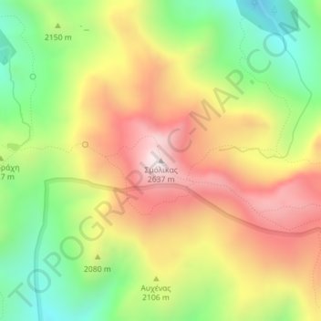
Σμόλικας topographic map
Interactive map
Click on the map to display elevation.
About this map
Name: Σμόλικας topographic map, elevation, terrain.
Average elevation: 2,199 m
Minimum elevation: 1,808 m
Maximum elevation: 2,607 m
Mount Smolikas (Greek: Σμόλικας; Aromanian: Smolcu) is a mountain in the Ioannina regional unit, northwestern Greece. At a height of 2,637 metres above sea level, it is the highest of the Pindus Mountains, and the second highest mountain in Greece after Mount Olympus. The mountain consists of ophiolite rocks. During several periods in the Pleistocene the northern and eastern cirques and valleys were glaciated. The last glaciers of this area retreated around 11,500 years ago. It is drained by the river Vjosa to the south, and the river Vourkopotamo (a tributary of the Sarantaporos) to the north. There is a small alpine lake called "Drakolimni Smolika" near the summit, at about 2,200 metres elevation. Nearby mountain ranges are Tymfi to the south, Gramos to the northwest, Vasilitsa to the southeast and Voio to the northeast.
Other topographic maps
Click on a map to view its topography, its elevation and its terrain.
Ioannina
Greece > Epirus and Western Macedonia > Ioannina Regional Unit
Ioannina, Ioannina Municipality, Ioannina Regional Unit, Epirus, Epirus and Western Macedonia, Greece
Average elevation: 493 m
Μικρό Πάπιγκο
Greece > Epirus and Western Macedonia > Ioannina Regional Unit
Μικρό Πάπιγκο, Zagori Municipality, Ioannina Regional Unit, Epirus, Epirus and Western Macedonia, 440 04, Greece
Average elevation: 1,237 m
Παρακάλαμος
Greece > Epirus and Western Macedonia > Ioannina Regional Unit
Παρακάλαμος, Pogoni Municipality, Ioannina Regional Unit, Epirus, Epirus and Western Macedonia, 440 04, Greece
Average elevation: 416 m
Ioannina
Greece > Epirus and Western Macedonia > Ioannina Regional Unit
Ioannina, Ioannina Municipality, Ioannina Regional Unit, Epirus, Epirus and Western Macedonia, 453 33, Greece
Average elevation: 724 m
Kalpaki
Greece > Epirus and Western Macedonia > Ioannina Regional Unit
Kalpaki, Dodoni Municipality, Ioannina Regional Unit, Epirus, Epirus and Western Macedonia, Greece
Average elevation: 1,068 m
Καστανιά
Greece > Epirus and Western Macedonia > Ioannina Regional Unit
Καστανιά, Konitsa Municipality, Ioannina Regional Unit, Epirus, Epirus and Western Macedonia, 440 15, Greece
Average elevation: 1,069 m
Μέτσοβο
Greece > Epirus and Western Macedonia > Ioannina Regional Unit
Μέτσοβο, Metsovo Municipality, Ioannina Regional Unit, Epirus, Epirus and Western Macedonia, 442 00, Greece
Average elevation: 1,318 m
Βραδέτο
Greece > Epirus and Western Macedonia > Ioannina Regional Unit > Καπέσοβο > Βραδέτο
Βραδέτο, Καπέσοβο, Zagori Municipality, Ioannina Regional Unit, Epirus, Epirus and Western Macedonia, 44018, Greece
Average elevation: 1,174 m
Perama
Greece > Epirus and Western Macedonia > Ioannina Regional Unit > Perama Municipal Unit
Perama, Perama Municipal Unit, Ioannina Municipality, Ioannina Regional Unit, Epirus, Epirus and Western Macedonia, 455 00, Greece
Average elevation: 653 m