
Cucutilla topographic map
Interactive map
Click on the map to display elevation.
About this map
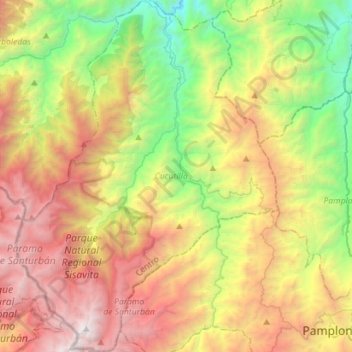
Name: Cucutilla topographic map, elevation, terrain.
Location: Cucutilla, Centro, Norte de Santander, Colombia (7.35946 -72.90162 7.63944 -72.68994)
Average elevation: 2,293 m
Minimum elevation: 758 m
Maximum elevation: 4,296 m
Other topographic maps
Click on a map to view its topography, its elevation and its terrain.
Toledo
Toledo, Suroriente, Norte de Santander, Colombia
Average elevation: 2,367 m
Las Palmeras
Colombia > Norte de Santander > Ocaña > Las Palmeras
Las Palmeras, Ocaña, Occidente, Norte de Santander, 546551, Colombia
Average elevation: 1,194 m
El Carmen
El Carmen, Occidente, Norte de Santander, RAP Gran Santander, Colombia
Average elevation: 528 m