Geolocate

Samaru topographic map

Click on the map to display elevation.

About this map

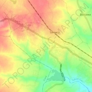
Name: Samaru topographic map, elevation, terrain.

Location: Samaru, Sabon Gari, Kaduna State, Nigeria (11.13922 7.61983 11.17216 7.68519)

Average elevation: 672 m

Minimum elevation: 630 m

Maximum elevation: 708 m

Other topographic maps

Click on a map to view its topography, its elevation and its terrain.

Zaria

Nigeria > Kaduna State > Sabon Gari

Average elevation: 655 m

Zaria

Nigeria > Kaduna State > Sabon Gari

Average elevation: 655 m

ABU Dam

Nigeria > Kaduna State > Sabon Gari > Jama A

Average elevation: 652 m

Gear up for your next adventure:

🚲Bikepacking Frame Bags - Storage for tools and navigation gear on long off-road rides
🥾Men's Waterproof Hiking Boots - Durable footwear with deep lugs for muddy and rocky UK terrains
🐕Dog Hiking Gear - Equipment for hiking safely with dogs
🧥Breathable Waterproof Jackets - Essential rain protection for the unpredictable British climate
🧷Tenacious Repair Tape - Instant fix for torn tents, jackets, or dry bags

As an Amazon Associate, this site earns from qualifying purchases at no extra cost to you.