
Make a donation
Gear up for your next adventure:
As an Amazon Associate, this site earns from qualifying purchases at no extra cost to you.
Bellavista topographic map
Click on the map to display elevation.
Make a donation
Gear up for your next adventure:
As an Amazon Associate, this site earns from qualifying purchases at no extra cost to you.
Bellavista
Es el segundo distrito más antiguo de toda la provincia. Su elevación distrital se dio el 6 de octubre de 1915 mediante la ley 2141, la cual también creó el distrito de La Punta. Es un distrito residencial consolidado y carente de espacio para expansión, se pueden distinguir 4 zonas residenciales diferentes: Cercado de Bellavista (sector histórico); Ciudad del Pescador; Urb. Virú y aledaños; y Urb. San Joaquín - San José.
Make a donation
Gear up for your next adventure:
As an Amazon Associate, this site earns from qualifying purchases at no extra cost to you.
About this map
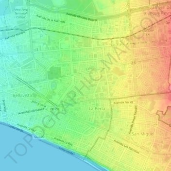
Name: Bellavista topographic map, elevation, terrain.
Location: Bellavista, Callao, Perú (-12.06784 -77.13424 -12.05171 -77.08714)
Average elevation: 32 m
Minimum elevation: 0 m
Maximum elevation: 71 m
Make a donation
Gear up for your next adventure:
As an Amazon Associate, this site earns from qualifying purchases at no extra cost to you.
Other topographic maps
Click on a map to view its topography, its elevation and its terrain.